mSpearX - Precision Awareness for Defense & Civil Resilience
“mSpearX: Centimeter-accurate intelligence. Trusted from frontline to frontier.
Introducing mSpearX: European-made dual-use UAS delivering real-time, RTK-precise geospatial intelligence — enabling both artillery fire correction and civil protection operations with the same secure, sovereign platform
The Problem:
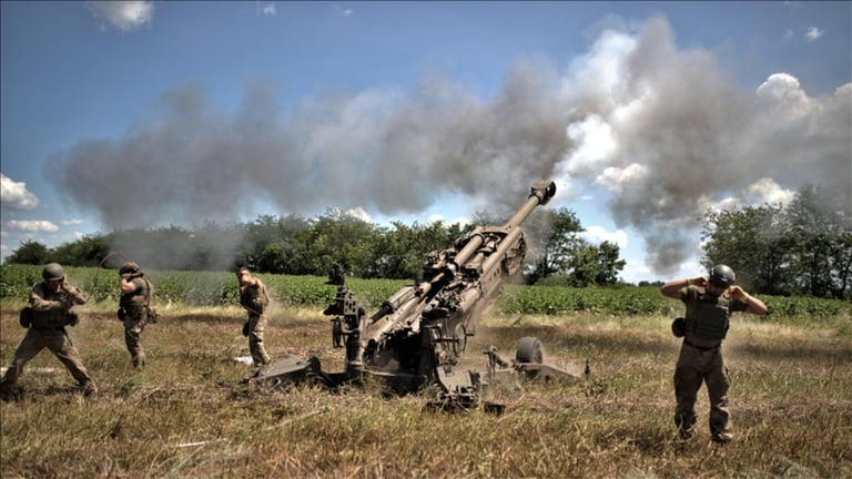
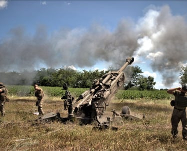
Artillery is blind without precise coordinates.
Modern artillery systems lose up to 50% of their effectiveness due to:
Inaccurate target coordinates – standard drones deliver 10–20 m positional errors.
Data transmission delays – up to 5 minutes to process imagery.
Risk to reconnaissance teams – personnel must enter high-threat zones to adjust fire.
Inability to operate at night or in obscurants – standard cameras fail in smoke, fog, or darkness.
Result: wasted ammunition, failed missions, and loss of personnel.
The Solution : mSpearX - it's your eye in the sky !
Mission
mSpearX is a high-precision correction UAV, designed to adjust artillery fire in real time, in both automatic and semi-automatic modes.
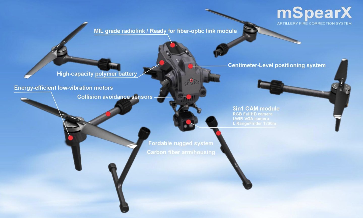
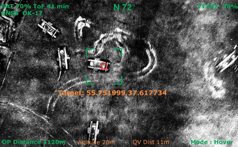
1. Launch – The operator initiates mSpearX; the drone climbs to 120 m in 20 seconds (fully automatic takeoff).
2. Real-time battlefield awareness – dual-sensor plus LRF payload:
RGB camera for daytime target identification.
LWIR thermal VGA camera for nighttime target identification.
Laser RangeFinder with working distance - 1200 meters.
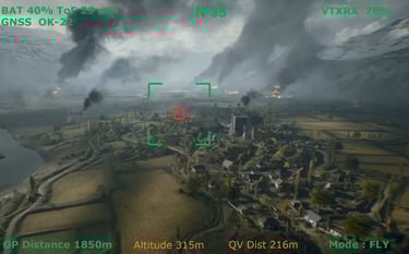
3. Target confirmation & engagement:
The operator places a reticle on the target (e.g., tank, bunker, vehicle concentration).
With a single button press, target coordinates accurate to ±0.5 m are transmitted within 3 seconds to the ballistic computer via an encrypted, GDPR-compliant channel or fiber-optic, EW-resilient link.
Artillery delivers first-round hits, even against moving targets (the drone refreshes coordinates every 3 seconds).
4. Human-in-the-loop – the operator confirms each target using two independent verification methods before coordinates are released.
5. One-button return – after mission completion, the drone automatically returns to its launch point.
for more details - please contact us: info@spearx.eu
mSpearX in development now. Since our projects involve sensitive technologies, we do not want to make internal achievements public.

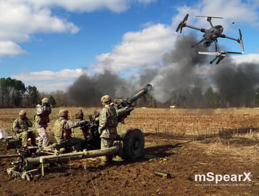

The photos of mSpearX illustrate various product variants during development and testing.
With mSpearX you get: coordinate accuracy of ±0.5 m reaction time 3 seconds secure data transmission (GDPR-compliant, EW-resistant, fiber optic ready) compliance with EASA class C6, STANAG 4671
How it works:

Why mSpearX:
Force protection: Operators remain 5 km behind the front line, dramatically improving survivability.
Warfare economics:
50% less ammunition needed per mission → direct budget savings.
Higher precision = fewer rounds to achieve mission success, without sacrificing effectiveness.
Seamless integration: Ready-to-deploy solution compatible with multiple ballistic computer systems.
Environmental impact:
50% reduction in ammunition use = 0.8 tonnes less CO₂ per artillery strike (calculated per European Environment Agency methodology).
Civilian-use mSpearX:
Originally engineered for high-stakes military missions, mSpearX is now reimagined for civilian use - bringing military-grade precision, resilience, and speed to critical civilian operations.
Equipped with dual-spectrum imaging (RGB + LWIR), a 1,200-meter laser rangefinder, and sub-meter geolocation accuracy (±0.5 m), mSpearX delivers real-time situational awareness - day or night, through smoke, fog, or dust.
Civil Applications:
Emergency Response: Locate survivors in disasters within seconds - even in total darkness or smoke-filled environments.
Infrastructure Inspection: Safely inspect power lines, pipelines, and wind turbines with thermal anomaly detection and precise distance measurement.
Wildfire & Environmental Monitoring: Detect hotspots early and map fire spread in real time.
Surveying & Construction: Achieve survey-grade accuracy without ground control points - fast, automated, and reliable.
Critical Site Security: Patrol perimeters autonomously and alert teams to intrusions with exact coordinates in under 3 seconds.
Built to EASA Class C6 standards and featuring jam-resistant, encrypted communications, mSpearX ensures secure, compliant operations in complex environments.
From battlefield to public service - precision that protects, saves, and builds
Contacts
SpearX ↑ Strike with Precision
+359 877 620 210
D-U-N-S® 525540791


© 2025. All rights reserved. SpearX Projects. Geocom Co. LLC