
Understanding Thermal UAV Camera Detection Ranges
Discover how atmospheric conditions impact the detection range of thermal UAV cameras and IR seekers. Learn about the significance of MWIR and LWIR bands and how to optimize performance in varying weather conditions. Ensure your system is equipped for real-world challenges beyond the lab.
7/23/20262 min read
What this looks like in the field:
Clear night - both bands deliver full range. Light haze - MWIR still reaches 6 km, LWIR drops to 4. Moderate fog (visibility ~200 m)- MWIR gets you 800 m, LWIR only 500. Dense fog (visibility 50 m) - both collapse under 200 m.
Rain is a separate headache. Each raindrop in the sensor's field of view becomes a tiny thermal noise source. Heavy rain raises the noise floor and buries small, low-contrast targets.
Dust and smoke don't just block signal - they flatten the entire thermal picture. No contrast, no detection.
So what actually helps?
1. Dual-band MWIR+LWIR with real-time weighted fusion. When LWIR optical depth exceeds threshold, algorithm upweights MWIR channel. Not a binary switch - a continuous blend.
2. Temporal integration (TDI). Trade frame rate for sensitivity. 60 Hz → 15 Hz buys ~6 dB in SNR. Enough to recover 30-40% of lost range in haze.
3. Adaptive NUC + edge-AI denoising. Non-uniformity correction drifts in thermal gradients. Scene-referenced NUC plus CNN trained on paired degraded/clean IR frames recovers contrast with low latency on FPGAs/SoC.
4. Validation beyond the lab. Climate chambers test window condensation and detector survival at -40 °C. They cannot replicate 2 km of atmospheric path. You need multi-season outdoor trials or MODTRAN/LOWTRAN simulations validated against local radiosonde and visibility data (HITRAN line-by-line for accuracy).
Important:
The atmosphere is not a static window. It changes every ten minutes. Any range number without weather conditions attached is marketing, not engineering.
Design for the worst morning, not the best afternoon.
Your IR seeker / thermal UAV camera detects a target at 12 km on a clear night. In moderate fog? 600 meters. In dense fog? 150 meters.
A 20x to 80x drop. And no datasheet will warn you about this.
I keep seeing "10 km detection range" in specs with zero mention of weather. Then the system ships, hits a November morning, and operators wonder why targets appear at 800 m. The sensor works fine. The atmosphere just isn't a vacuum.
Here's the physics in plain terms:
IR signal fades exponentially with distance through air. In clear dry conditions, it barely fades at all. Add water droplets, and every meter of path eats a chunk of your signal. Double the fog density, and you don't lose twice the range - you lose it much faster than that.
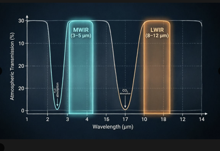
Two IR bands matter :
→ MWIR (3-5 µm): sees hot things - exhausts, engines. Scatters off fog droplets but holds up relatively well.
→ LWIR (8-12 µm): sees thermal contrast against background. Gets absorbed by water vapor more aggressively.
Related : GEOCOM Co. LLC www.geocomco.eu DeepTechRnD www.deeptechrnd.eu SpearXAgro www.spearxagro.eu
Contacts
SpearX ↑ Strike with Precision
+359 877 620 210
D-U-N-S® 525540791


© 2025 - 2026. All rights reserved. SpearX Projects. Geocom Co. LLC



SpearX is an EU-Ukrainian company located in a strategic areas for R&D in UAV