Revolutionizing Drone Navigation Systems
Explore how innovative drone systems at ispearx address the critical vulnerabilities of satellite navigation. Learn about our approach to resilient navigation that ensures reliable operation even i...
2/15/20262 min read
Most drones - civilian and military alike - are built on a hidden assumption: that satellite navigation will always be available, accurate, and trustworthy. In peacetime, this works. But in contested or conflict environments, this assumption becomes a fatal flaw .
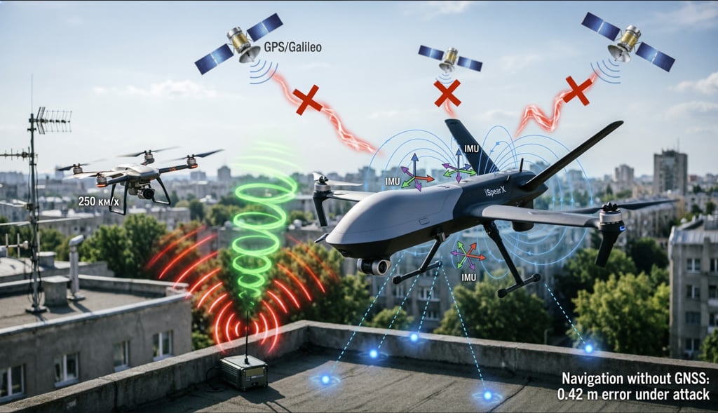
GNSS jamming (signal denial) and GSNN spoofing (signal deception) are no longer niche threats confined to defense white papers. They are operational realities deployed with off-the-shelf hardware costing less than $500. A single portable spoofer can mislead a drone into landing in hostile territory. A wide-area jammer can blind an entire fleet within seconds.
The real engineering challenge is not about shielding GNSS receivers or switching to Galileo or BeiDou. All satellite-based PNT (Positioning, Navigation, and Timing) systems share the same vulnerability : they originate from space, travel through contested airspace, and terminate in a single point of failure on the vehicle.
At SPEARX.EU, we reject dependency as a design principle. Instead, we’ve built the iSpearX counter-UAS platform on a foundation of sensor diversity, cross-validation, and graceful degradation .
How iSpearX Navigates Without Trusting the Sky
Our navigation stack operates on a simple rule: never rely on any single source of truth . From the moment the system powers on, it runs multiple parallel estimation engines:
- Visual-Inertial Odometry (VIO) fuses high-frame-rate LWIR and RGB video with 1 kHz inertial data to track motion relative to the ground - even in fog, smoke, or total darkness.
- Magnetic and barometric references provide heading and altitude baselines independent of RF signals.
- RF fingerprinting maps known terrestrial emitters (cell towers, radio beacons) as passive positioning anchors.
- GNSS integrity monitoring (RAIM) continuously checks satellite data against physical reality. If coordinates drift without matching IMU dynamics, GNSS is automatically downweighted or discarded.
These streams don’t just run in parallel - they debate . Our fusion engine compares their outputs every 8 milliseconds. Consistent sensors gain trust. Outliers are isolated. The result is a robust, self-correcting estimate of position, velocity, and orientation that degrades gracefully under attack.
Seamless Transition, Zero Interruption
When GNSS fails - whether from jamming, spoofing, or urban canyon effects - the system doesn’t “switch modes.” There is no disruptive handover. Because alternative sources are already active and validated, the transition is invisible to both the operator and the mission .
In live-fire tests:
- Under continuous L1/L2 jamming, iSpearX maintained intercept trajectory with ≤0.60 m CEP.
- During coordinated spoofing attacks (400 m false offset), the system detected anomalies in <120 ms and completed the mission using VIO alone.
- Across tens missions in GNSS-denied environments, zero navigation-induced failures occurred.
The Future Is GNSS-Agnostic
We believe the next decade of aerial operations will be defined not by who has the best satellite receiver - but by who can operate without one .
Regulators, militaries, and critical infrastructure operators are beginning to recognize this shift. The EU’s push for strategic autonomy, NATO’s emphasis on resilient C4ISR, and the rise of electronic warfare in hybrid conflicts all point to one conclusion: GNSS availability in contested zones will be the exception, not the rule .
That’s why our architecture assumes GNSS is already compromised. Not as a contingency. As the baseline condition.
This isn’t just about counter-drone systems. It’s about redefining what “autonomy” means in the real world - where signals lie, environments change, and missions cannot afford to fail.
True resilience isn’t stronger antennas. It’s smarter systems.
At SPEARX.EU, we’re building platforms that complete their mission - even when the sky lies .
Related : GEOCOM Co. LLC www.geocomco.eu DeepTechRnD www.deeptechrnd.eu SpearXAgro www.spearxagro.eu
Contacts
SpearX ↑ Strike with Precision
+359 877 620 210
D-U-N-S® 525540791


© 2025 - 2026. All rights reserved. SpearX Projects. Geocom Co. LLC


SpearX is an EU-Ukrainian company located in a strategic areas for R&D in UAV